Every renovation, retrofit, or facility upgrade starts with one basic question: what does the existing site actually look like today? Drawings go out of date, buildings get modified without updated records, and guesswork on site conditions leads to costly surprises mid-project. Genesis Infoserve's Point Cloud & Reality Capture Solutions give architects, engineers, contractors, and facility owners an accurate, measurable digital record of existing conditions, so every decision from that point forward is based on what's actually there, not what the drawings say should be there.
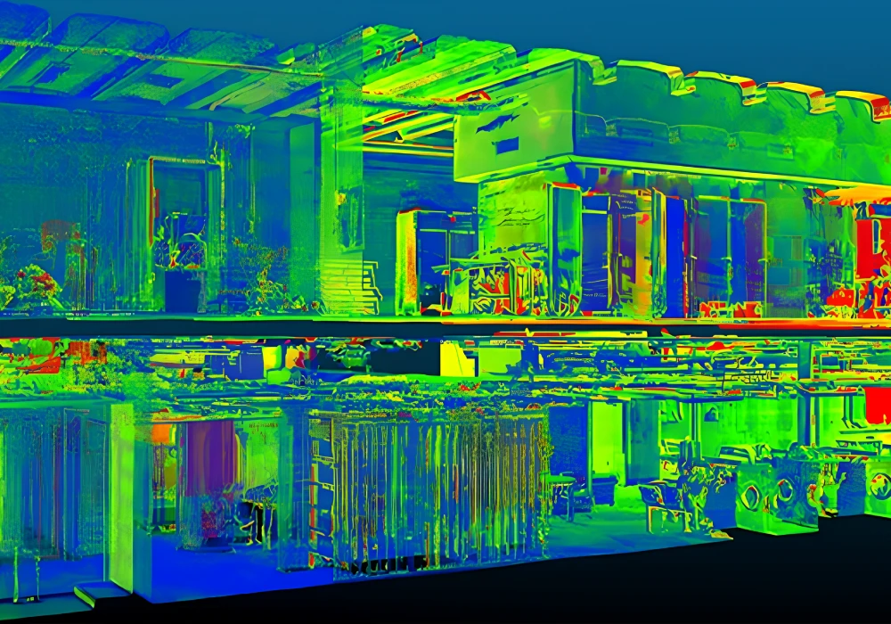
Read More Read MoreReality capture is the umbrella term for technologies and workflows used to record the physical, as-built condition of a site, building, or asset in digital form. Instead of relying on manual measurements or outdated as-built drawings, teams use tools such as laser scanners, drones, and mobile mapping devices to capture millions of precise measurements in a fraction of the time traditional surveying would take. The output is a point cloud, a massive set of X, Y, Z coordinates representing every surface, edge, and object the scanner recorded, effectively a digital snapshot of the physical space at the moment it was captured. This approach has become standard practice in the USA and globally across several industries because it removes ambiguity from a process that used to rely heavily on assumptions:
From Laser Scan To Point Cloud
Capturing a site is only the first step. A typical point cloud scanuses LiDAR (Light Detection and Ranging) technology, sending out laser pulses and measuring the time each takes to bounce back to calculate exact distance and build a dense, three-dimensional map of the space. Depending on the project, this can involve:
This data collection process typically produces raw scan output in the millions or billions of measurements, which then needs to be registered, cleaned, and aligned into a single, accurate coordinate system before it's usable for design or analysis.
Raw scan output isn't useful on its own, it must be processed into something design and engineering teams can work with. Once cleaned and registered, this dataset becomes the foundation for scan-to-BIM modeling, clash detection, as-built documentation, and deformation or progress monitoring over time.
Working directly from a point cloud during design or renovation planning avoids costly site revisits, reduces the risk of clashes between new work and existing conditions, and gives every stakeholder- architects, MEP engineers, structural teams, and contractors- a shared, accurate reference instead of relying on conflicting field notes and outdated drawings.
Our process is built to turn raw scan data into something your project team can actually design and build from:
Reviewing site access, complexity, and project goals to determine the right capture method and scan resolution.
Conducting the on-site scan using terrestrial, mobile, or drone-based equipment, depending on the environment and deliverables required.
Stitching individual scans together into one continuous, accurately aligned dataset tied to real-world coordinates.
Removing noise, unwanted objects (people, vehicles, temporary equipment), and redundant data to produce a manageable, accurate dataset.
Modeling the captured conditions into intelligent Revit elements, where required, so the data can be used directly in design workflows.
Exporting in the format your team needs, including RCP, RCS, E57, and other standard scan and coordination formats.
Every point cloud we deliver is cleaned, aligned, and registered to your coordinated systems, so it drops directly into your existing workflow without additional rework on your end.
This type of digital record isn't limited to one project phase. It supports teams:
Genesis Infoserve's reality captureservices support these workflows across industries, including commercial real estate, industrial facilities, infrastructure, healthcare, and historic preservation projects, wherever an accurate digital record of physical space adds value to the decision being made.
Every engagement begins with understanding what the final deliverables need to support. This starts with a short discovery conversation about the site, access constraints, and intended use of the data, whether that's design coordination, facility documentation, or construction verification, before any equipment is deployed on site. That planning step is what keeps scan resolution, coverage, and turnaround time aligned with what the project actually needs, rather than over- or under-capturing the space, and it's what separates a usable dataset from a generic scan that ends up needing rework later.
Skipping proper documentation, or relying on a rushed scan, tends to cost more later than it saves upfront. Poorly registered or incomplete data can lead to:
A properly planned and executed capture avoids all of this by giving every downstream team, from design through facility management, one accurate, shared reference to work from.
Choosing the right partner for this kind of work affects how usable the final dataset actually is. With Genesis Infoserve, you get:
If your project needs an accurate, reliable digital record of existing conditions, Genesis Infoserve's reality capture expertise is built to give your teams a dataset they can actually design, build, and manage from.
A point cloud is a massive set of X, Y, Z coordinates that represents every surface, edge, and object captured during a scan. It's generated using tools like laser scanners, drones, or mobile mapping devices that measure millions of points across a site, effectively creating a digital snapshot of the physical space as it exists today.
Traditional surveying relies on manual measurements taken point by point, which is slow and prone to gaps. Reality capture uses laser scanning, drone-based capture, or photogrammetry to record millions of measurements at once, producing a far more complete and accurate record of existing conditions in a fraction of the time.
We deliver in the formats your team already works with, including RCP, RCS, and E57, along with scan-to-BIM Revit models when your project requires modeled elements rather than raw scan data.
Yes, once a site is captured and cleaned, that dataset becomes a reliable as-built baseline that facility teams can reference for maintenance planning, renovations, or future space changes, without relying on outdated original drawings.
When properly registered and cleaned, scan data is typically far more accurate and complete than manual measurements, since it captures every surface in dense detail rather than relying on selective spot checks. Accuracy also depends on the capture method chosen and how carefully the data is processed afterward.
It depends on how the data will be used. If your team just needs a visual or dimensional reference, the cleaned point cloud alone is often sufficient. If you need intelligent, schedulable elements for design coordination, clash detection, or documentation, scan-to-BIM conversion turns that raw data into usable Revit families and components.


Genesis Infoserve stands as a distinguished leader in BIM services.